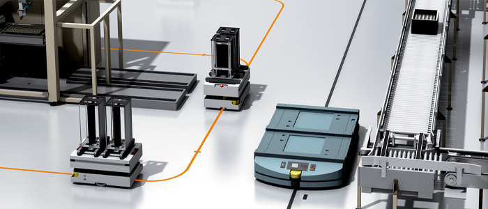
With the launch of its LiDAR-LOC 2 solution, SICK has made it easy to teach mobile machines virtual paths in order to enhance, expand, or replace physical floor-based guidance systems that use taped lines or 2D-codes.
The SICK LiDAR-LOC 2 is the first step in a major upgrade programme for SICK’s LiDAR Localisation-on-Contour software, which uses data from SICK 2D LiDAR sensors or safety scanners to create a reference map based on the contours of shop floors and warehouses and guide automated transport, stacking and loading systems. The upgrade lays the foundations for users, machine builders and developers to progress from localisation, using LiDAR position and orientation data, to being able to integrate full navigation to control the movement of all kinds of automated guided vehicles, carts, forklifts, or service robots.
Virtual Line Guidance
The SICK LiDAR-LOC 2 is a virtual line guidance system designed to enhance the physical line or code-reading systems of all kinds of automated mobile robots. It creates a virtual path to bridge a gap in a broken tape on the floor, or to add a deviation from the current line-guided path without having to go to the time and expense of laying down new lines or bar codes.
Simply teach the vehicle the route by moving it along the desired path, then refine the uploaded map data using the SICK visualisation software tool via an easy-to-follow graphic user interface. The system automatically patches the existing reference map or can merge the data with the existing map.
Neil Sandhu, SICK’s UK Product Manager for Imaging, Measurement, Ranging and Systems explains: “While the original LiDAR-LOC provided an option for expert developers and integrators to use the raw data for navigation, in addition to the localisation information, the LiDAR-LOC 2 upgrade is based on a desire to make it much quicker and easier to use data from sensors to tell a mobile vehicle how to get from ‘A to B’.
“As a result, it promises to save the development time and cost, machine space and wiring complexity involved in integrating navigation, because separate software and controls are not needed. In the case of our first LiDAR-LOC 2 release, managers of mobile vehicle fleets using line or code guidance can much more easily alter vehicle paths or optimise their routes. Stoppages because of breaks in a line can be avoided, especially in high-traffic areas.”
Increased Fleet Availability
The SICK LiDAR-LOC 2 reduces fleet downtime from vehicle stoppages due to missing lines or codes. New routes can be commissioned without stopping the vehicle. Additionally, users can use analytical functions in the system to optimise vehicle routes, for example, by detecting where tape is no longer needed and can be removed. The system also offers a progression for users to dispense eventually with floor-based guidance and adopt a completely contour-based navigation system.
Enabled by LiDAR-LOC software running on a SICK Sensor Integration Machine, the SICK LiDAR-LOC 2 can be retrofitted to already-installed scanners. It can be integrated with SICK line sensors or 2D-code readers, as well as with encoders for motion control and odometry.
Major Platform Upgrade
The upgraded SICK LiDAR-LOC 2 solution achieves improved accuracy up to ≤ 10mm. In addition to the SICK Sensor Integration Machines, it can now be installed on third party controllers with common operating systems including Windows, Linux, Ubuntu and Raspberry Pi OS Lite. New APIs for streaming and configuration have been introduced for UDP, REST and COLA2.
For more information on the SICK LiDAR-LOC 2, please contact Andrea Hornby on 01727 831121 or email andrea.hornby@sick.co.uk.
www.sick.co.uk